Blog Post
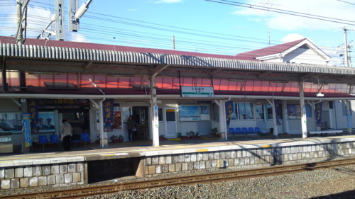
Tomioka Train Station (Before Being Destroyed by Tsunami)
wastholm.tumblr.com/post/3884874228/tomioka-train-station-before-being-destroyed-by, posted 2011 by peter in fukushima japan travel
Just thought I’d post a couple of photos that we happened to take of the Tomioka train station on our last visit to Fukushima. We’ve been told that the entire station has now been completely swept away by the tsunami. These photos are from Dec. 29, 2010 and, as you can see, it was a cold and windy day.
Blog Post
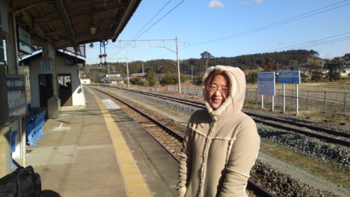
Tomioka Train Station (Before Being Destroyed by Tsunami)
wastholm.tumblr.com/post/3884874228/tomioka-train-station-before-being-destroyed-by, posted 2011 by peter in fukushima japan travel
Just thought I’d post a couple of photos that we happened to take of the Tomioka train station on our last visit to Fukushima. We’ve been told that the entire station has now been completely swept away by the tsunami. These photos are from Dec. 29, 2010 and, as you can see, it was a cold and windy day.
Blog Post
Map Showing Location of Our Relatives in Fukushima
wastholm.tumblr.com/post/3877883966/map-showing-location-of-our-relatives-in-fukushima, posted 2011 by peter in fukushima japan jpquake
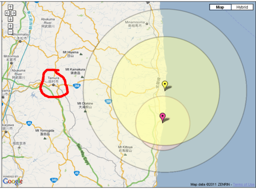
My wife’s mom, her husband, and his mother are in Tamura, about 40 km from the disaster-struck Fukushima Daiichi power plant, the yellow pin on the map. The yellow circle shows the 20-km evacuation zone; the larger circle indicates the 30-km zone in which people are advised to stay indoors and keep windows closed. Their house is about half way between the Daiichi and Daini power plants. (The latter, indicated by the pink pin, also had problems earlier but the situation there now seems to be under control.) The house is near the town of Tomioka, whose train station, which has often served as our starting point for trips around Japan, has been completely washed away by the tsunami.
Blog Post
Map Showing Location of Our Relatives in Fukushima
wastholm.tumblr.com/post/3877883966/map-showing-location-of-our-relatives-in-fukushima, posted 2011 by peter in fukushima japan jpquake
My wife’s mom, her husband, and his mother are in Tamura, about 40 km from the disaster-struck Fukushima Daiichi power plant, the yellow pin on the map. The yellow circle shows the 20-km evacuation zone; the larger circle indicates the 30-km zone in which people are advised to stay indoors and keep windows closed. Their house is about half way between the Daiichi and Daini power plants. (The latter, indicated by the pink pin, also had problems earlier but the situation there now seems to be under control.) The house is near the town of Tomioka, whose train station, which has often served as our starting point for trips around Japan, has been completely washed away by the tsunami.
Blog Post
Photos from Evacuation Shelter in Fukushima, Japan (Corrected)
wastholm.tumblr.com/post/3873930611/photos-from-evacuation-shelter-in-fukushima-japan, posted 2011 by peter in fukushima japan jpquake
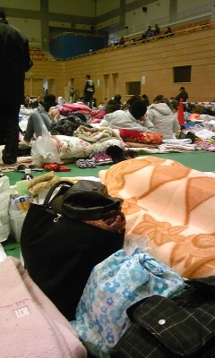
7 Photos
Blog Post
Photos from Evacuation Shelter in Fukushima, Japan (Corrected)
wastholm.tumblr.com/post/3873930611/photos-from-evacuation-shelter-in-fukushima-japan, posted 2011 by peter in fukushima japan jpquake
7 Photos
|< First < Previous 91–96 (96)
Your Host
Hello,
![[photo]](/images/peter_autumn)
my name is Peter Wastholm and I'm a consultant and entrepreneur i Stockholm, Sweden. Here's a presentation, of sorts. You can also find me here: